
National Scenic Byway
Utah Highway 12
Part 1
National Scenic Byway
Utah Highway 12
Part 1
Last year when Mrs. C. and I did the Four Canyons Ride, I became
curious about Hwy. 12 that runs from Hwy. 89 (Bryce Canyon) to Hwy. 24 in central Utah. After doing some further investigation
about this road, I found that it was in fact a National Scenic Byway, one of only 27 roads in the United
States that had earned this lofty recognition. Highway 12 in Utah is also often listed as one of the
top 10 scenic drives in the United States right alongside Highway 1 in California, the Million Dollar Highway
in Colorado and the Going-to-the-Sun Road in Glacier National Park. Once you have traveled this road, you will
not have to ask why. We have seen a lot of beautiful scenery over the last several years and this route is one
of the best.
We decided to shave a couple of hours off our day by spending Thursday night in Munds
Park with our friends Dan and Kathy at the McKinnon Inn. After a quick
breakfast at the Lone Pine Friday morning, we were on the road by 8:30 am with our first destination being
Zion National Park. Mrs. C. and I had already been through Zion, but it is one of those places that is a treat
to ride through more than once. We took Hwy. 89 out of Flagstaff to 89A where we would ride past the Vermillion
Cliffs with a detour down to Lee's Ferry. If you take this
route, the 5 mile ride down to the Colorado
River and Lee's Ferry is well worth the trip. This is where
a lot of the rafting trips on the Colorado begin.
We continued on 89A past the Vermillion cliffs and through the pines past Jacob Lake where we had reached
7900 feet before our descent into Fredonia and Kanab where we stopped for lunch.
We were now only 30 miles from the entrance of Zion and our first taste of the geologic
marvel of this beautiful National Park. It now costs $12 per motorcycle
to go through these parks. Knowing that we would be going through at least 2 more National Parks in the near future,
we decided to buy the annual National Park pass for $80. Just an FYI, this allows 2 motorcycles and their designated
riders that have signed the card to enter any and all National parks for a year. So if you just go through
3 you are pretty close to break even and you have a whole year to use it. The ride through Zion is only 20 miles but
it takes you through beautiful white sandstone mountains,
red rocks, elevation
changes, a mile long tunnel through the mountain
and switchbacks that leave you wanting more. The good news is that you do get more. After a break in
the small town of Springdale which is the West entrance of Zion, you turn right around and go back through
Zion to get to Hwy. 89 to continue your trip to Bryce and Hwy. 12. While in Zion, stop by and feed the Elk on the North side of the road.
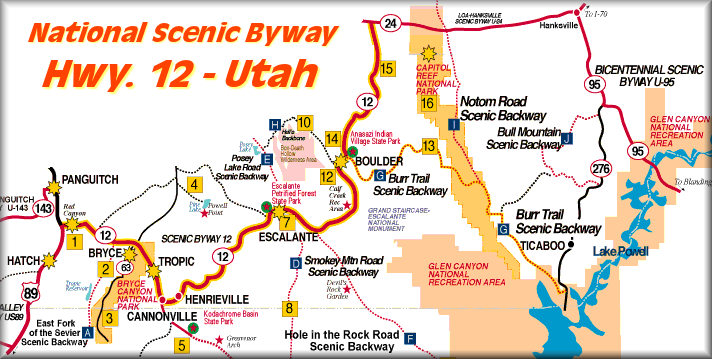
Once back to 89 you will go North for about 40 miles until you reach Scenic Byway 12.
A couple of miles into 12 you will enter Red Canyon to get your first
taste of what Bryce Canyon will look like. This is a beautiful 5 mile ride that will have you in awe
of the beauty of the pink and red sandstone outcroppings that
are right next to the road. For the next 7 miles you will gradually climb to around 7500 feet in elevation
as you reach the entrance to Bryce Canyon National Park. It was now 7pm for us and time to call it a day after
369 miles and 10 hours on the road. Due to all of the rooms in Bryce being full, we decided to stay at the Bryce
Valley Inn in Tropic located 7 miles East of Bryce. Just as an FYI, you can look at the GPS to see our statistics
for Friday. Click Here.
Saturday morning we were on the road by 8am to visit Bryce Canyon National Park. If
you have never been here, you are missing one of the most unique and beautiful geological wonders of our
entire country. Bryce is a 17 mile ride to the end with 10 overlooks along the way ending your 1500 foot
climb at Rainbow Point. You will
want to allow at least 2-3 hours to ride the 17 miles into Bryce, stop at the overlooks and then back out.
Click
Here for photos of Bryce Canyon National Park.
It was now 11:00am and we were on our way to the highlight of our ride, National Scenic Byway 12,
Utah's first All-American Road. I will admit that the hype on this road was
high and I only hoped that it would be half as good as what I was expecting. After dropping into the Bryce Canyon valley through Tropic, Cannonville and Henrieville, we started our winding ascent through the
Dixie
National Forest toward the small town of Escalante. This
part of the trip will take you through some farmland surrounded by Plateaus rolling small sandstone mountains covered
in small pine with the Escalante Staircase Monument on your right heading North.
The 27 mile ride Northeast from Escalante to Boulder contains absolutely fantastic
scenery and is also known as the Million Dollar Road to Boulder.
This section of Scenic Byway 12 was built by the Civilian Conservation Corps and completed in 1935 (paved in 1971)
providing the first year round access for automobiles to this isolated part of Southwestern Utah. About
10 miles from Escalante you will round a sharp corner that will open up
the white Slickrock Canyons and the road far below that you will
soon be riding on. Make sure and stop at the pullout to really take in the 35 mile view that surrounds
you. The next 17 miles will take you up and down through the beautiful white and red rock sandstone canyons and across
the Hogback, a short section of the road built on a ridge with sharp dropoffs on both sides,
on your way to Boulder. Click Here for an aerial view. Shortly after the Hogback you will drop into the Boulder Valley. There is a great
place to eat right at the 90 degree turn called the Burr Trail Grill.
If you are inclined and have the time, the locals say that the Burr Trail is a beautiful
ride that takes you down to the Capital Reef and to Lake Powell. But
the locals suggest to take the first 12 miles to Long Canyon and then turn around and come back. Everyone said
it is spectacular and well worth the ride. We didn't have time, so I will have to catch it on the next trip through
here. I know it will not be the last. Approximately 30 of the next 37 miles will take you on a winding road through
the Dixie National forest to as high as 9600 feet with endless views of Capital
Reef and Eastern Utah before coming back down the hill to the small town of Torrey signaling the end of National
Scenic Byway 12 as it intersects Hwy. 24.
I was trying to come up with the words to describe this route and I ran across a description
on MSN Travel. They described it with words I could not improve on.
Here is what they say. Highway 12: "Windswept red-rock canyons, towering sandstone formations, pristine lakes,
and pine-studded mountain ranges combine for an altogether over-the-top sensory experience in Southern Utah. The
setting for several stunning national parks, this remarkable road connects those at Bryce Canyon and Capitol Reef,
and offers unique beauty and seemingly limitless recreational opportunities on a stretch of land between the two
parks' boundaries. Utah Highway 12, also known as Highway 12 Scenic Byway, is one of only 27 nationally designated
All-American Roadsthe highest honor a road can get for attractive scenery. This spectacular route travels away
from Bryce Canyon, through the Grand Staircase-Escalante National Monument, and over the forested Boulder Mountain
and the Dixie National Forest, before winding down near the entrance to Capitol Reef. The scenery is unforgettable
along the entire length of the roadespecially during the brilliant red-rock sunsets that provide a glorious grand
finale to a day's driving adventure here." That pretty much sums it up.
I give Highway 12 a Cyclerides.com rating of 5 out of 5 Spokes. I would encourage anyone to make this trip. It takes 3 long days for the entire round trip
to Phoenix, but if you start early in the mornings, it is easily done and very rewarding. Check the weather in
the different areas of this route as much of it is in the high elevations and it does get snow. I would
think you could easily go till mid October. It might be cool in the mornings but would warm up.
This is only 1/2 of the 1200 mile ride from Phoenix. We
continued on Hwy. 24 through Capital Reef National Park, down Hwy. 95 through Glen Canyon Recreation area, down
the Muki Dugway, Gooseneck State Park and through Monument Valley before heading back to Phoenix. I will be
back in 3 weeks with the remainder of the ride and some more great photos. Click Here for the Maps of Route.
I have split these 270 photos up into 3 groups for easier viewing. I encourage you to
look at these beautiful pictures.
Click
Here for Zion National Park.
Click Here
for Bryce Canyon National Park.
Click
Here for National Scenic Byway 12.
Useful Links:
Top 10 Scenic
Drives in the U.S. Hwy. 12 is number 4.
Scenic Byway 12.
This is a great interactive site.
Utah.com.
Lot's of information on the area.
Byways.org. Good information on a lot of byways.
Stops along scenic byway 12.
Zion National Park.
Wikipedia: Zion National Park
All information in this newsletter is
Copyright © 2007 BDC Products, LLC.
Information may be used only with permission.
All rights reserved.